![](/images/other/stat-length.png)
![Excursión A pie Hof van Twente - WNW Twente - Schoolbuurt/Elsen -oranje route - Photo](https://media.geolcdn.com/t/1900/400/bc920386-2aa6-4086-94fe-47a5c33e1595.jpeg&format=pjpeg&maxdim=2)
WNW Twente - Schoolbuurt/Elsen -oranje route
SityTrail - itinéraires balisés pédestres
Tous les sentiers balisés d’Europe GUIDE+
![Longitud](/images/other/stat-length.png)
Longitud
10,7 km
![Altitud máxima](https://static1.geolcdn.com/siteimages/upload/files/1508320355ic_sort_altitude_max_24dp.png)
Altitud máxima
21 m
![Desnivel positivo](https://static1.geolcdn.com/siteimages/upload/files/1508320355ic_sort_den_pos_24dp.png)
Desnivel positivo
58 m
![Km-Effort](/images/other/stat-length.png)
Km-Effort
11,5 km
![Altitud mínima](https://static1.geolcdn.com/siteimages/upload/files/1508320355ic_sort_altitude_min_24dp.png)
Altitud mínima
8 m
![Desnivel negativo](https://static1.geolcdn.com/siteimages/upload/files/1508320355ic_sort_den_neg_24dp.png)
Desnivel negativo
58 m
![Boucle](https://static1.geolcdn.com/siteimages/upload/files/16400158638029165_repeat_loop_refresh_sync_direction_icon.png)
Boucle
Sí
Baliza
Fecha de creación :
2022-02-14 15:13:22.954
Última modificación :
2022-02-14 15:13:22.954
![A pie](https://static1.geolcdn.com/sitytour/trail-icons/100.png)
2h36
Dificultad : Fácil
![Escanee este código QR para abrir la excursión en la aplicación SityTrail](https://capi.geolives.com/qq0zvz2zws4bq2lad0pu/sitytour/trails/3109746/qr.png?size=200)
Aplicación GPS de excursión GRATIS
A propósito
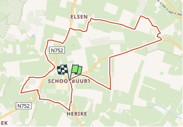
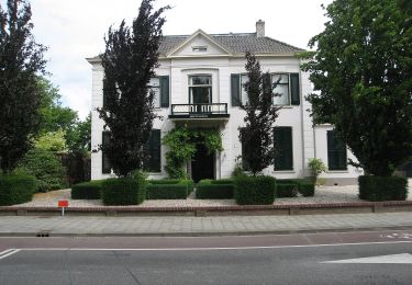
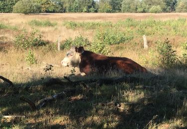
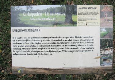
Ruta A pie de 10,7 km a descubrir en Overijssel, Desconocido, Hof van Twente. Esta ruta ha sido propuesta por SityTrail - itinéraires balisés pédestres.
Descripción
Trail created by Routenetwerken Twente.
Localización
País:
Netherlands
Región :
Overijssel
Departamento/provincia :
Desconocido
Municipio :
Hof van Twente
Localidad:
Unknown
Salida:(Dec)
Salida:(UTM)
331707 ; 5792369 (32U) N.
Comentarios
Excursiones cerca
![Excursión A pie Hof van Twente - Kerkepaden-Tichelroutes Markelo - Photo](https://media.geolcdn.com/t/375/260/bbc35e8b-1526-4f9b-b205-9961540e79b8.jpeg&format=jpg&maxdim=2)
![A pie A pie](https://static1.geolcdn.com/sitytour/trail-icons/100.png)
Kerkepaden-Tichelroutes Markelo
A pie
Fácil
Hof van Twente,
Overijssel,
Desconocido,
Netherlands
![](/images/other/stat-length.png)
6,2 km | 7,3 km-effort
1h 40min
![](https://static1.geolcdn.com/siteimages/upload/files/16400158638029165_repeat_loop_refresh_sync_direction_icon.png)
No
![Excursión A pie Rijssen-Holten - WNW Twente - De Keizer - rode route - Photo](https://media.geolcdn.com/t/375/260/3ff1c8fc-bd33-4f73-851f-c2da5134bcee.jpeg&format=jpg&maxdim=2)
![A pie A pie](https://static1.geolcdn.com/sitytour/trail-icons/100.png)
WNW Twente - De Keizer - rode route
A pie
Fácil
Rijssen-Holten,
Overijssel,
Desconocido,
Netherlands
![](/images/other/stat-length.png)
6,1 km | 6,5 km-effort
1h 28min
![](https://static1.geolcdn.com/siteimages/upload/files/16400158638029165_repeat_loop_refresh_sync_direction_icon.png)
Sí
![Excursión A pie Rijssen-Holten - WNW Twente - De Welle - groene route - Photo](https://media.geolcdn.com/t/375/260/ab7d65bf-1621-46c9-9f06-4381bd705581.jpeg&format=jpg&maxdim=2)
![A pie A pie](https://static1.geolcdn.com/sitytour/trail-icons/100.png)
WNW Twente - De Welle - groene route
A pie
Fácil
Rijssen-Holten,
Overijssel,
Desconocido,
Netherlands
![](/images/other/stat-length.png)
3,9 km | 4,2 km-effort
57min
![](https://static1.geolcdn.com/siteimages/upload/files/16400158638029165_repeat_loop_refresh_sync_direction_icon.png)
Sí
![Excursión A pie Rijssen-Holten - WNW Twente - Klein-Zwitserland - groene route - Photo](https://media.geolcdn.com/t/375/260/c849c2c5-34ca-45ad-b6d9-5b7f7313f6ef.jpeg&format=jpg&maxdim=2)
![A pie A pie](https://static1.geolcdn.com/sitytour/trail-icons/100.png)
WNW Twente - Klein-Zwitserland - groene route
A pie
Fácil
Rijssen-Holten,
Overijssel,
Desconocido,
Netherlands
![](/images/other/stat-length.png)
4,5 km | 5,1 km-effort
1h 9min
![](https://static1.geolcdn.com/siteimages/upload/files/16400158638029165_repeat_loop_refresh_sync_direction_icon.png)
Sí
![Excursión A pie Hof van Twente - WNW Twente - Bovenberg/Elsen - groene route - Photo](https://media.geolcdn.com/t/375/260/65d397e9-130d-4f0e-a427-9b4be6f93fff.jpeg&format=jpg&maxdim=2)
![A pie A pie](https://static1.geolcdn.com/sitytour/trail-icons/100.png)
WNW Twente - Bovenberg/Elsen - groene route
A pie
Fácil
Hof van Twente,
Overijssel,
Desconocido,
Netherlands
![](/images/other/stat-length.png)
5,7 km | 6,1 km-effort
1h 23min
![](https://static1.geolcdn.com/siteimages/upload/files/16400158638029165_repeat_loop_refresh_sync_direction_icon.png)
Sí
![Excursión A pie Hof van Twente - WNW Twente -Schoolbuurt - groene route - Photo](https://media.geolcdn.com/t/375/260/bc920386-2aa6-4086-94fe-47a5c33e1595.jpeg&format=jpg&maxdim=2)
![A pie A pie](https://static1.geolcdn.com/sitytour/trail-icons/100.png)
WNW Twente -Schoolbuurt - groene route
A pie
Fácil
Hof van Twente,
Overijssel,
Desconocido,
Netherlands
![](/images/other/stat-length.png)
10,5 km | 11,2 km-effort
2h 32min
![](https://static1.geolcdn.com/siteimages/upload/files/16400158638029165_repeat_loop_refresh_sync_direction_icon.png)
Sí
![Excursión A pie Hof van Twente - WNW Twente - Markelo/Pothoek - gele route - Photo](https://media.geolcdn.com/t/375/260/a0bd5499-ebd0-4f2c-ac61-22d69f766646.jpeg&format=jpg&maxdim=2)
![A pie A pie](https://static1.geolcdn.com/sitytour/trail-icons/100.png)
WNW Twente - Markelo/Pothoek - gele route
A pie
Fácil
Hof van Twente,
Overijssel,
Desconocido,
Netherlands
![](/images/other/stat-length.png)
6,8 km | 7,4 km-effort
1h 41min
![](https://static1.geolcdn.com/siteimages/upload/files/16400158638029165_repeat_loop_refresh_sync_direction_icon.png)
Sí
![Excursión A pie Hof van Twente - WNW Twente - Markelo/Pothoek - rode route - Photo](https://media.geolcdn.com/t/375/260/8a3fe254-6a3e-4be1-8e7b-7d2c36b5add7.jpeg&format=jpg&maxdim=2)
![A pie A pie](https://static1.geolcdn.com/sitytour/trail-icons/100.png)
WNW Twente - Markelo/Pothoek - rode route
A pie
Fácil
Hof van Twente,
Overijssel,
Desconocido,
Netherlands
![](/images/other/stat-length.png)
11 km | 11,9 km-effort
2h 41min
![](https://static1.geolcdn.com/siteimages/upload/files/16400158638029165_repeat_loop_refresh_sync_direction_icon.png)
Sí
![Excursión A pie Hof van Twente - WNW Twente - Kattenberg - rode route - Photo](https://media.geolcdn.com/t/375/260/14b666bb-f81e-4e7e-8869-cfb0f739d5c8.jpeg&format=jpg&maxdim=2)
![A pie A pie](https://static1.geolcdn.com/sitytour/trail-icons/100.png)
WNW Twente - Kattenberg - rode route
A pie
Fácil
Hof van Twente,
Overijssel,
Desconocido,
Netherlands
![](/images/other/stat-length.png)
10,7 km | 11,2 km-effort
2h 33min
![](https://static1.geolcdn.com/siteimages/upload/files/16400158638029165_repeat_loop_refresh_sync_direction_icon.png)
Sí